Close Menu
Meteorological Technology International
  • News
    • A-E
      • Agriculture
      • Automated Weather Stations
      • Aviation
      • Climate Measurement
      • Data
      • Developing Countries
      • Digital Applications
      • Early Warning Systems
      • Extreme Weather
    • G-P
      • Hydrology
      • Lidar
      • Lightning Detection
      • New Appointments
      • Nowcasting
      • Numerical Weather Prediction
      • Polar Weather
    • R-S
      • Radar
      • Rainfall
      • Remote Sensing
      • Renewable Energy
      • Satellites
      • Solar
      • Space Weather
      • Supercomputers
    • T-Z
      • Training
      • Transport
      • Weather Instruments
      • Wind
      • World Meteorological Organization
      • Meteorological Technology World Expo
  • Features
  • Online Magazines
    • January 2026
    • April 2025
    • January 2025
    • September 2024
    • April 2024
    • Archive Issues
    • Subscribe Free!
  • Opinion
  • Videos
  • Supplier Spotlight
  • Expo
LinkedIn X (Twitter) Facebook
  • Sign-up for Free Weekly E-Newsletter
  • Meet the Editors
  • Contact Us
  • Media Pack
LinkedIn Facebook
Subscribe
Meteorological Technology International
  • News
      • Agriculture
      • Automated Weather Stations
      • Aviation
      • Climate Measurement
      • Data
      • Developing Countries
      • Digital Applications
      • Early Warning Systems
      • Extreme Weather
      • Hydrology
      • Lidar
      • Lightning Detection
      • New Appointments
      • Nowcasting
      • Numerical Weather Prediction
      • Polar Weather
      • Radar
      • Rainfall
      • Remote Sensing
      • Renewable Energy
      • Satellites
      • Solar
      • Space Weather
      • Supercomputers
      • Training
      • Transport
      • Weather Instruments
      • Wind
      • World Meteorological Organization
      • Meteorological Technology World Expo
  • Features
  • Online Magazines
    1. January 2026
    2. September 2025
    3. April 2025
    4. January 2025
    5. September 2024
    6. April 2024
    7. January 2024
    8. September 2023
    9. April 2023
    10. Archive Issues
    11. Subscribe Free!
    Featured
    November 27, 2025

    In this Issue – January 2026

    By Hazel KingNovember 27, 2025
    Recent

    In this Issue – January 2026

    November 27, 2025

    In this Issue – September 2025

    August 11, 2025

    In this Issue – April 2025

    April 15, 2025
  • Opinion
  • Videos
  • Supplier Spotlight
  • Expo
Facebook LinkedIn
Subscribe
Meteorological Technology International
Satellites

Europe launches Sentinel-1C radar satellite

Elizabeth BakerBy Elizabeth BakerDecember 17, 20243 Mins Read
Share LinkedIn Facebook Twitter Email
Credit: European Union, Copernicus Sentinel-1 imagery. This Sentinel-1 image acquired on November 24, 2024, shows the flooded areas near the towns of Langport, Bridgwater and Yeovil in the UK in red tones.
Share
LinkedIn Facebook Twitter Email

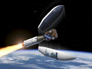
The Sentinel-1C satellite has been launched on a VEGA-C rocket and will orbit 700km above the Earth’s surface. Part of Europe’s Copernicus program, it will use advanced radar technology to provide continuous imaging over land and sea, day and night, and even through cloud cover.

Advanced radar imaging

Airbus Defence and Space (Portsmouth) developed the electronics subsystem of the key synthetic aperture radar (SAR) instrument on board the satellite. Honeywell UK was responsible for the receiver of the automated identification system (AIS) payload, which will be key for maritime surveillance capabilities. The battery for Sentinel-1C was supplied by Enersys ABSL (Abingdon).

Science Minister Lord Vallance said, “The successful launch of this new satellite will further strengthen the Copernicus program, which continues to collect vital long-term data allowing us to better understand our planet, respond to natural disasters and tackle global challenges like climate change.”

Consistent long-term data

Once it reaches its intended orbit, Sentinel-1C will synchronize with Sentinel-1A, which is already in space. These satellites will work in partnership with each other to deliver the Sentinel-1 mission, imaging the Earth and generating large amounts of data that is fed into the various services provided by Copernicus.

Credit ESA – P. Carril

Unlike research satellites, Sentinel-1C imagery is designed to sustain a reliable operational service, with consistent and long-term data collection for key applications. This is crucial for land and maritime monitoring, tracking of sea ice, emergency response to flooding and earthquake events, tracking climate variables and assessing the impacts of climate change.

Prof. John Remedios, director of the National Centre for Earth Observation, commented, “The advent of operational radar satellites has been a huge boost to our ability to observe hazardous and extreme environments, for example where people are vulnerable to earthquakes and volcanoes. Sentinel-1C will renew the extensive coverage and clever products which result from combining data from two radar satellites operating at the same time, allowing scientists and businesses to measure ground motion from glaciers to cities.”

This latest milestone for Copernicus follows the successful launch of another satellite – Sentinel-2C – in September this year. This satellite is already providing high-resolution imagery and data, as a powerful tool that enhances the UK and Europe’s capabilities in monitoring land and vegetation.

In related news, the first of EUMETSAT’s Meteosat Third Generation (MTG) satellites recently became fully operational and is disseminating high-resolution, accurate data for predicting severe weather events. MTG-Imager 1 has also received a new name – Meteosat-12 – to mark the occasion. Click here to read the full story.

Previous ArticleVIDEO: Researchers develop generative AI climate model that’s 25 times faster than current models
Next Article University of Washington forecasts Antarctic sea ice levels months in advance

Read Similar Stories

Space Weather

Northumbria University secures £4m to study Earth’s radiation belts

April 16, 20262 Mins Read
Extreme Weather

AI model improves real-time prediction of wildfire spread

April 16, 20263 Mins Read
Climate Measurement

Study identifies atmospheric trigger behind flash droughts in Puerto Rico

April 15, 20263 Mins Read
Latest News

Northumbria University secures £4m to study Earth’s radiation belts

April 16, 2026

AI model improves real-time prediction of wildfire spread

April 16, 2026

Study identifies atmospheric trigger behind flash droughts in Puerto Rico

April 15, 2026

Receive breaking stories and features in your inbox each week, for free


Enter your email address:


Supplier Spotlights
  • GAMIC GmbH
Getting in Touch
  • Contact Us / Advertise
  • Meet the Editors
  • Media Pack
  • Free Weekly E-Newsletter
Our Social Channels
  • Facebook
  • LinkedIn
© 2026 UKi Media & Events a division of UKIP Media & Events Ltd
  • Cookie Policy
  • Privacy Policy
  • Terms and Conditions
  • Notice and Takedown Policy

Type above and press Enter to search. Press Esc to cancel.