Close Menu
Meteorological Technology International
  • News
    • A-E
      • Agriculture
      • Automated Weather Stations
      • Aviation
      • Climate Measurement
      • Data
      • Developing Countries
      • Digital Applications
      • Early Warning Systems
      • Extreme Weather
    • G-P
      • Hydrology
      • Lidar
      • Lightning Detection
      • New Appointments
      • Nowcasting
      • Numerical Weather Prediction
      • Polar Weather
    • R-S
      • Radar
      • Rainfall
      • Remote Sensing
      • Renewable Energy
      • Satellites
      • Solar
      • Space Weather
      • Supercomputers
    • T-Z
      • Training
      • Transport
      • Weather Instruments
      • Wind
      • World Meteorological Organization
      • Meteorological Technology World Expo
  • Features
  • Online Magazines
    • January 2026
    • April 2025
    • January 2025
    • September 2024
    • April 2024
    • Archive Issues
    • Subscribe Free!
  • Opinion
  • Videos
  • Supplier Spotlight
  • Expo
LinkedIn X (Twitter) Facebook
  • Sign-up for Free Weekly E-Newsletter
  • Meet the Editors
  • Contact Us
  • Media Pack
LinkedIn Facebook
Subscribe
Meteorological Technology International
  • News
      • Agriculture
      • Automated Weather Stations
      • Aviation
      • Climate Measurement
      • Data
      • Developing Countries
      • Digital Applications
      • Early Warning Systems
      • Extreme Weather
      • Hydrology
      • Lidar
      • Lightning Detection
      • New Appointments
      • Nowcasting
      • Numerical Weather Prediction
      • Polar Weather
      • Radar
      • Rainfall
      • Remote Sensing
      • Renewable Energy
      • Satellites
      • Solar
      • Space Weather
      • Supercomputers
      • Training
      • Transport
      • Weather Instruments
      • Wind
      • World Meteorological Organization
      • Meteorological Technology World Expo
  • Features
  • Online Magazines
    1. January 2026
    2. September 2025
    3. April 2025
    4. January 2025
    5. September 2024
    6. April 2024
    7. January 2024
    8. September 2023
    9. April 2023
    10. Archive Issues
    11. Subscribe Free!
    Featured
    November 27, 2025

    In this Issue – January 2026

    By Hazel KingNovember 27, 2025
    Recent

    In this Issue – January 2026

    November 27, 2025

    In this Issue – September 2025

    August 11, 2025

    In this Issue – April 2025

    April 15, 2025
  • Opinion
  • Videos
  • Supplier Spotlight
  • Expo
Facebook LinkedIn
Subscribe
Meteorological Technology International
Aviation

NASA pilots high-altitude balloon with compact 3D atmospheric imaging sensor

Elizabeth BakerBy Elizabeth BakerNovember 6, 20242 Mins Read
Share LinkedIn Facebook Twitter Email
Two payloads successfully flew a four-week test aboard a World View high-altitude balloon with support from NASA’s Flight Opportunities program.
Credit: NASA
Share
LinkedIn Facebook Twitter Email

Two payloads have successfully flown a four-week test aboard a World View high-altitude balloon with support from NASA’s Flight Opportunities program.

Compact 3D imaging sensor

CubeSounder

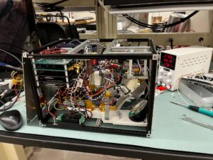
Reaching altitudes up to 81,000ft (24,688m), the World View high-altitude balloon carried the CubeSounder weather forecasting technology developed by researchers at Arizona State University in Tempe. Data collected during the 28-day flight is helping to advance this technology. CubeSounder collected data to help validate its high-altitude performance. CubeSounder is a compact 3D imaging sensor that collects atmospheric temperature and humidity data as 3D images for weather forecasting in a smaller package than current atmospheric sounders.

Automated radiation measurements for aerospace safety

Space Environment Technologies’ ARMAS dual monitor technology

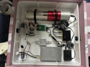
The flight also tested Space Environment Technologies’ automated radiation measurements for aerospace safety (ARMAS) dual monitor technology. For four weeks straight, ARMAS performed 24/7 radiation monitoring at aviation altitudes for the first time ever. Designed to enhance aviation safety by monitoring radiation exposure from cosmic rays, solar particles and Van Allen belt particles, ARMAS measured the full column of radiation at various altitudes within the same time and location using total ionizing dose and gamma-ray instruments. ARMAS also has support from NASA’s Small Business Innovation Research (SBIR) program.

In related news, NASA’s Coronal Diagnostic Experiment (CODEX) will launch to the International Space Station in November 2024 to collect data on solar wind, including its origin and evolution. Click here to read the full story.

Previous ArticleNSF launches field campaigns in snow, hail and air pollution
Next Article VIDEO: WMO produces a multi-agency report on global climate services

Read Similar Stories

Satellites

AI tool uses weather satellite data to map ocean currents in near real time

April 14, 20263 Mins Read
Climate Measurement

New tool speeds up climate model evaluation

April 13, 20262 Mins Read
Climate Measurement

China inaugurates 27th national climate observatory in Hebei

April 9, 20262 Mins Read
Latest News

Northumbria University secures £4m to study Earth’s radiation belts

April 16, 2026

AI model improves real-time prediction of wildfire spread

April 16, 2026

Study identifies atmospheric trigger behind flash droughts in Puerto Rico

April 15, 2026

Receive breaking stories and features in your inbox each week, for free


Enter your email address:


Supplier Spotlights
  • Sommer GmbH
Getting in Touch
  • Contact Us / Advertise
  • Meet the Editors
  • Media Pack
  • Free Weekly E-Newsletter
Our Social Channels
  • Facebook
  • LinkedIn
© 2026 UKi Media & Events a division of UKIP Media & Events Ltd
  • Cookie Policy
  • Privacy Policy
  • Terms and Conditions
  • Notice and Takedown Policy

Type above and press Enter to search. Press Esc to cancel.