Close Menu
Meteorological Technology International
  • News
    • A-E
      • Agriculture
      • Automated Weather Stations
      • Aviation
      • Climate Measurement
      • Data
      • Developing Countries
      • Digital Applications
      • Early Warning Systems
      • Extreme Weather
    • G-P
      • Hydrology
      • Lidar
      • Lightning Detection
      • New Appointments
      • Nowcasting
      • Numerical Weather Prediction
      • Polar Weather
    • R-S
      • Radar
      • Rainfall
      • Remote Sensing
      • Renewable Energy
      • Satellites
      • Solar
      • Space Weather
      • Supercomputers
    • T-Z
      • Training
      • Transport
      • Weather Instruments
      • Wind
      • World Meteorological Organization
      • Meteorological Technology World Expo
  • Features
  • Online Magazines
    • January 2026
    • April 2025
    • January 2025
    • September 2024
    • April 2024
    • Archive Issues
    • Subscribe Free!
  • Opinion
  • Videos
  • Supplier Spotlight
  • Expo
LinkedIn X (Twitter) Facebook
  • Sign-up for Free Weekly E-Newsletter
  • Meet the Editors
  • Contact Us
  • Media Pack
LinkedIn Facebook
Subscribe
Meteorological Technology International
  • News
      • Agriculture
      • Automated Weather Stations
      • Aviation
      • Climate Measurement
      • Data
      • Developing Countries
      • Digital Applications
      • Early Warning Systems
      • Extreme Weather
      • Hydrology
      • Lidar
      • Lightning Detection
      • New Appointments
      • Nowcasting
      • Numerical Weather Prediction
      • Polar Weather
      • Radar
      • Rainfall
      • Remote Sensing
      • Renewable Energy
      • Satellites
      • Solar
      • Space Weather
      • Supercomputers
      • Training
      • Transport
      • Weather Instruments
      • Wind
      • World Meteorological Organization
      • Meteorological Technology World Expo
  • Features
  • Online Magazines
    1. January 2026
    2. September 2025
    3. April 2025
    4. January 2025
    5. September 2024
    6. April 2024
    7. January 2024
    8. September 2023
    9. April 2023
    10. Archive Issues
    11. Subscribe Free!
    Featured
    November 27, 2025

    In this Issue – January 2026

    By Hazel KingNovember 27, 2025
    Recent

    In this Issue – January 2026

    November 27, 2025

    In this Issue – September 2025

    August 11, 2025

    In this Issue – April 2025

    April 15, 2025
  • Opinion
  • Videos
  • Supplier Spotlight
  • Expo
Facebook LinkedIn
Subscribe
Meteorological Technology International
Data

CAMS research reveals global fire emissions are decreasing despite extreme hotspots

Hazel KingBy Hazel KingDecember 14, 20203 Mins Read
Share LinkedIn Facebook Twitter Email
Share
LinkedIn Facebook Twitter Email

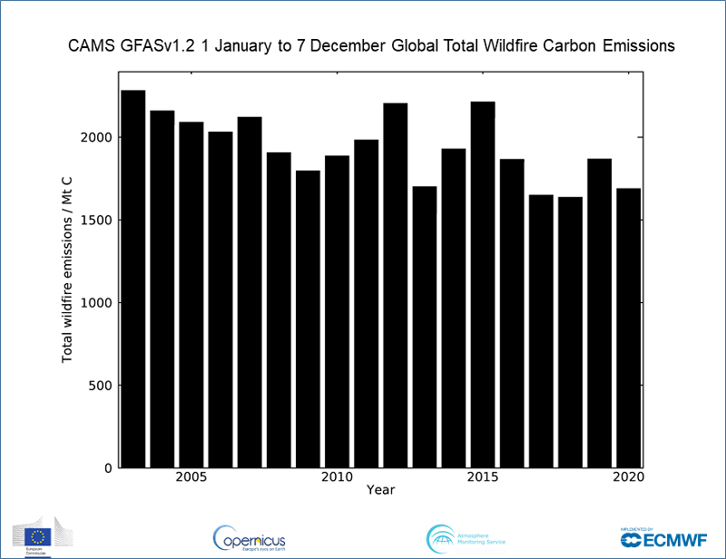
New research from the Copernicus Atmosphere Monitoring Service (CAMS), which has spent the year tracking the devastating wildfires that have occurred in several hotspots across the world, has revealed that despite some regions such as the western USA being particularly badly hit, there have been fewer wildfires across the globe, continuing a trend of declining emissions since 2003.

 CAMS scientists monitor daily wildfire activity around the world using a measure of heat output called Fire Radiative Power (FRP). These observations come from satellite-based sensors which can detect the heat signal and are used to estimate the intensity of fires. The CAMS Global Fire Assimilation System (GFAS) uses these near-real-time observations of the location and intensity of active wildfires to estimate the emissions of pollutants. To illustrate fire activity in 2020, CAMS has created a designated animation. Furthermore, CAMS scientists can confirm that 2020 has seen one of the lowest years of fire activity in its GFAS data set, which began in 2003, but in the worst affected areas, the intensity has been far higher.

While fire activity in southern tropical Africa has been very low this year, there has been enhanced activity in areas such as Siberia, Colorado, California and the Pantanal region of southern Brazil. In 2020, approximately 1,690 megatonnes of carbon have been discharged into the atmosphere from January 1 to December 7, 2020. This compares to 1,870 megatonnes of carbon emitted in 2019 and continues the pattern of lower emissions.

Mark Parrington, senior scientist and wildfire expert at CAMS, explained, “While 2020 has certainly been a devastating year for wildfires in the most badly affected hotspots, emissions across the world have been lower due to better fire management and mitigation measures. Since we began monitoring wildfires via our GFAS system in 2003, we have seen a gradual decline in emission rates. However, this is no time to be complacent as wildfires in the worse affected areas were of record intensity as a result of warmer, drier conditions. This resulted in increased pollutants being carried thousands of miles, affecting air quality for millions of people.

“By continuing to monitor the scale, intensity and emissions of these wildfires on a daily basis across the globe, our aim is to raise awareness of their long-lasting and large-scale impact. This helps inform policymakers, organizations, businesses and the individual citizen to plan against the potential effects of air pollution, particularly important now that the Covid-19 pandemic has hit us.”

You can find more information, animations and graphs about this year’s wildfires here.

Global total estimated wildfire carbon emission for January 1 to December 7, 2020. CAMS data shows a generally decreasing trend since 2003, with 2020 one of the lowest years on record. Credit: Copernicus Atmosphere Monitoring Service, ECMWF.
Previous ArticleNSF approves funding for next stage of NCAR’s new solar observatory
Next Article Aerosols in Indo-Gangetic Plain increase rainfall in Himalayan foothills

Read Similar Stories

Extreme Weather

AI model improves real-time prediction of wildfire spread

April 16, 20263 Mins Read
Climate Measurement

Study identifies atmospheric trigger behind flash droughts in Puerto Rico

April 15, 20263 Mins Read
Satellites

AI tool uses weather satellite data to map ocean currents in near real time

April 14, 20263 Mins Read
Latest News

Northumbria University secures £4m to study Earth’s radiation belts

April 16, 2026

AI model improves real-time prediction of wildfire spread

April 16, 2026

Study identifies atmospheric trigger behind flash droughts in Puerto Rico

April 15, 2026

Receive breaking stories and features in your inbox each week, for free


Enter your email address:


Supplier Spotlights
  • Meteorage
Getting in Touch
  • Contact Us / Advertise
  • Meet the Editors
  • Media Pack
  • Free Weekly E-Newsletter
Our Social Channels
  • Facebook
  • LinkedIn
© 2026 UKi Media & Events a division of UKIP Media & Events Ltd
  • Cookie Policy
  • Privacy Policy
  • Terms and Conditions
  • Notice and Takedown Policy

Type above and press Enter to search. Press Esc to cancel.