Close Menu
Meteorological Technology International
  • News
    • A-E
      • Agriculture
      • Automated Weather Stations
      • Aviation
      • Climate Measurement
      • Data
      • Developing Countries
      • Digital Applications
      • Early Warning Systems
      • Extreme Weather
    • G-P
      • Hydrology
      • Lidar
      • Lightning Detection
      • New Appointments
      • Nowcasting
      • Numerical Weather Prediction
      • Polar Weather
    • R-S
      • Radar
      • Rainfall
      • Remote Sensing
      • Renewable Energy
      • Satellites
      • Solar
      • Space Weather
      • Supercomputers
    • T-Z
      • Training
      • Transport
      • Weather Instruments
      • Wind
      • World Meteorological Organization
      • Meteorological Technology World Expo
  • Features
  • Online Magazines
    • January 2026
    • April 2025
    • January 2025
    • September 2024
    • April 2024
    • Archive Issues
    • Subscribe Free!
  • Opinion
  • Videos
  • Supplier Spotlight
  • Expo
LinkedIn X (Twitter) Facebook
  • Sign-up for Free Weekly E-Newsletter
  • Meet the Editors
  • Contact Us
  • Media Pack
LinkedIn Facebook
Subscribe
Meteorological Technology International
  • News
      • Agriculture
      • Automated Weather Stations
      • Aviation
      • Climate Measurement
      • Data
      • Developing Countries
      • Digital Applications
      • Early Warning Systems
      • Extreme Weather
      • Hydrology
      • Lidar
      • Lightning Detection
      • New Appointments
      • Nowcasting
      • Numerical Weather Prediction
      • Polar Weather
      • Radar
      • Rainfall
      • Remote Sensing
      • Renewable Energy
      • Satellites
      • Solar
      • Space Weather
      • Supercomputers
      • Training
      • Transport
      • Weather Instruments
      • Wind
      • World Meteorological Organization
      • Meteorological Technology World Expo
  • Features
  • Online Magazines
    1. January 2026
    2. September 2025
    3. April 2025
    4. January 2025
    5. September 2024
    6. April 2024
    7. January 2024
    8. September 2023
    9. April 2023
    10. Archive Issues
    11. Subscribe Free!
    Featured
    November 27, 2025

    In this Issue – January 2026

    By Hazel KingNovember 27, 2025
    Recent

    In this Issue – January 2026

    November 27, 2025

    In this Issue – September 2025

    August 11, 2025

    In this Issue – April 2025

    April 15, 2025
  • Opinion
  • Videos
  • Supplier Spotlight
  • Expo
Facebook LinkedIn
Subscribe
Meteorological Technology International
Climate Measurement

Minimum Arctic Ocean sea ice area in 2021 was largest of past seven years

Elizabeth BakerBy Elizabeth BakerFebruary 17, 20223 Mins Read
Share LinkedIn Facebook Twitter Email
Fig 1: The year’s smallest sea area covered with ice on September 12, 2021, and open periods of the Northern Sea Route Northeast Passage (left) and the Northwest Passage (right).
Share
LinkedIn Facebook Twitter Email

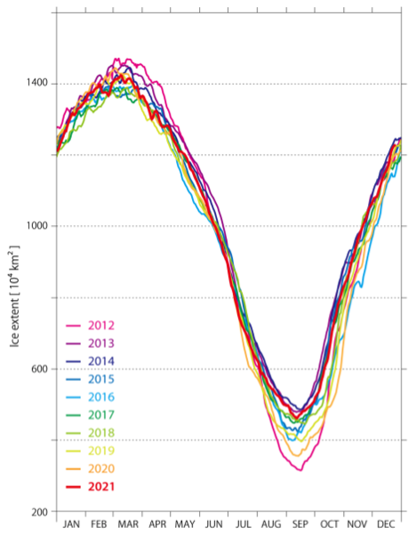
In its review of Arctic Ocean sea ice conditions during 2021, the global ice conditions forecaster Weathernews Global Ice Center found that the minimum sea ice area for the year was the largest of the past seven years at 4,610,000km2 .

Furthermore, both the Northeast (Russian side) and the Northwest (Canadian side) passages of the Northern Sea Route (NSR) in the Arctic Ocean remained closed. (Weathernews defines “open” as a state in which the entire route can be traversed without entering any areas affected by sea ice, according to satellite data.) This is the first time in 12 years since 2009 that the Northeast Passage did not open. Voyages traveling between Asia and Europe via the NSR reduce not only transportation costs but also CO2 emissions.

The decline in sea ice area has been accelerating in recent years due to increases in water temperature, with the Arctic region warming at a rate two to three times faster than other regions.

During the preceding 2020 season, in particular, the Northern Sea Route was open for the longest period ever, at 88 days, owing to the record-breaking high temperatures in the Arctic region. On the other hand, the summer temperature trends during 2021 were lower than usual in July, which is the usual period of melting. This caused less than the average amount of sea ice melting. As a result, sea ice remained in some areas of the Northern Sea Route even in September when the sea ice area should be the smallest, causing both the Northeast and the Northwest Passages to remain closed.

Fig 2: The year’s smallest sea area covered with ice on September 12, 2021 (Proprietary analysis image using the AMSR2 microwave satellite).

In order to achieve greenhouse gas (GHG) reduction targets, the International Maritime Organization (IMO) adopted the carbon intensity indicator (CII) rating scheme in June 2021 as a new regulation applicable to large ocean-going vessels. As a result, the environmental performance of a vessel will be evaluated on the basis of its annual energy efficiency starting in 2023, making fuel-economy improvement measures imperative for shipowners and ship management companies.

Weathernews began offering a Carbon Intensity Monitoring (CIM) Service, a CO2 emission monitoring service for the shipping industry, in April 2021. By combining the CIM Service with Weathernews’ traditional OSR (Optimum Ship Routing) Service for the selection of optimum routes, it supports the environmental measures of the shipping industry through digital technologies by realizing ecocentric voyages and visualization of the resulting reduction in emissions. Given the adoption of the new rating scheme, it is believed that the use of the Northern Sea Route, which can reduce CO2 emissions, will continue to increase.

Meanwhile, even though Arctic Ocean sea ice is on a declining trend, sea ice remaining along the coast due to seasonal weather conditions, as was the case this year, can pose the risk of accidents. In order to support safe navigation through the Northern Sea Route, Weathernews will continue to conduct detailed observation and analyses of Arctic Ocean sea ice by using proprietary microsatellites and prediction models to provide more accurate information on sea ice.

Fig 3: Changes in the area of sea ice extent since 2012 (by year).
Previous ArticleCold patch in the North Atlantic helping to stall glacier loss in Iceland
Next Article Nominations open for 2022 Sergej Zilitinkevich Memorial Award

Read Similar Stories

Climate Measurement

Study identifies atmospheric trigger behind flash droughts in Puerto Rico

April 15, 20263 Mins Read
Satellites

AI tool uses weather satellite data to map ocean currents in near real time

April 14, 20263 Mins Read
Climate Measurement

New tool speeds up climate model evaluation

April 13, 20262 Mins Read
Latest News

Northumbria University secures £4m to study Earth’s radiation belts

April 16, 2026

AI model improves real-time prediction of wildfire spread

April 16, 2026

Study identifies atmospheric trigger behind flash droughts in Puerto Rico

April 15, 2026

Receive breaking stories and features in your inbox each week, for free


Enter your email address:


Supplier Spotlights
  • ROTRONIC AG
Getting in Touch
  • Contact Us / Advertise
  • Meet the Editors
  • Media Pack
  • Free Weekly E-Newsletter
Our Social Channels
  • Facebook
  • LinkedIn
© 2026 UKi Media & Events a division of UKIP Media & Events Ltd
  • Cookie Policy
  • Privacy Policy
  • Terms and Conditions
  • Notice and Takedown Policy

Type above and press Enter to search. Press Esc to cancel.